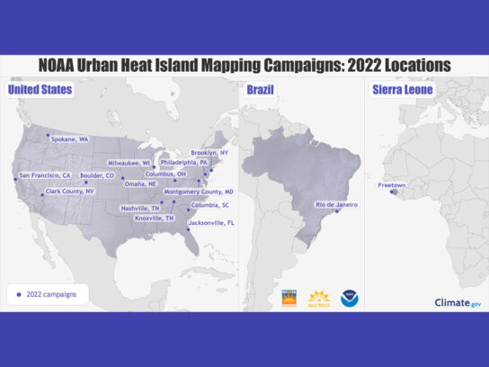
This summer, the National Oceanic and Atmospheric Administration (NOAA) will map heat inequities in Montgomery County to better combat extreme heat.
The county is among 14 communities nationally and two internationally that NOAA will monitor using heat sensors mounted on the cars and bikes of volunteers, according to a news release.
NOAA chose Montgomery County for heat mapping because it is an “urban heat island,” or a neighborhood that can become over 20 degrees hotter than nearby communities.
Today at the #NIHHISNational Meeting, NOAA Admin @rickspinradnoaa announced the locations of the 2022 NOAA Urban Heat Island Mapping Campaigns! Read the @NOAA press release to learn more.@CAPAstrategies#HeatHealth #UrbanHeatMaps2022https://t.co/83rbWKq4u4 pic.twitter.com/9acuiOqdJo
— NOAA Climate.gov (@NOAAClimate) April 26, 2022
“Extreme heat kills more Americans than any other weather event and has the greatest impact on our nation’s most vulnerable communities,” Deputy Secretary of Commerce Don Graves said in the release. “Fortunately, our talented and dedicated researchers and scientists at NOAA are working directly with communities across the country to help them take action to manage extreme heat. As climate change worsens heat waves, this critical information will help bring local and equitable solutions for those facing the greatest threats.”
Photo credit NOAA website.


Comments are closed.