I am fortunate to be a member of a team of experienced researchers and explorers who meet via Zoom every month or two to discuss our on-going efforts to solve the disappearance of Amelia Earhart and her navigator, Fred Noonan. In this column back in 2021 I detailed the 3.5 (!) major theories, and since then there have been some interesting developments in the case, which I will discuss below and next month.
Deep Sea Vision
In January 2024, Tony Romeo and his Deep Sea Vision (DSV) team made headlines around the world when they spotted what they thought might be Amelia Earhart’s Lockheed 10-E Electra in 16,000 feet of seawater (fsw), about 100 miles west of Howland Island, in the north Pacific just above the Equator. Tiny Howland was one of the last destinations for the aviators on their ill-fated 1937 around-the-world flight attempt.
DSV is a robotics company based in Charleston, South Carolina, and uses an autonomous underwater vehicle (AUV), the HUGIN 6000. Their HUGIN was called the “Miss Millie Pollywog,” after the nickname “Millie” that Amelia’s family used for her. The impressive AUV can search at depths down to almost 20,000 fsw.
When I saw the blurry image made public by DSV (see the photos below), I thought that it was possibly a plane but if it was, it was most likely a swept wing fighter like the North American F-86 Sabers used in the Korean War. Alternatively, I thought it was a natural formation. I knew that the Earhart plane had a very strong main spar that ran 22 feet across the plane from the right to the left engine, through the fuselage, and that two wing breaks right beside the fuselage, as shown in the image, were extremely unlikely.
Sure enough, in November 2024 the DSV team revisited the site for a closer look, and concluded that the object was actually a rock formation, not the missing aircraft. To their credit, the DSV team continued to search, covering 1,500 square nautical miles using underwater drones, but did not spot any other anomaly.
National Archives and Navy Yard Searches
My own searches, conducted at the National Archives I and II in DC and Maryland in 2023 and 2024, were a bit more productive. At NA I in DC I found the logs of the USS Bushnell, which surveyed Gardner Island (now Nikumaroro in the Republic of Kiribati), which may be where Earhart and Noonan landed and survived for one or two weeks. (This theory is
largely based on Earhart’s last radio transmission, saying, “We are on the line 157 337.” Extending the 337 degrees line southward hits the Phoenix Islands group, including Gardner/Nikumaroro.)
The Bushnell survey took place in 1939, just two years after the disappearance. The logs and associated maps and soundings revealed that the surveyors covered the island’s lagoon in great detail, and were on land too, erecting towers and markers. Thus, they likely would have spotted any large parts of wreckage in the lagoon or on the fringing reef, and might have spotted items left by the wrecked aviators, if indeed they survived there. (Remember, negative evidence is evidence.)
In the photo images section at NA II in Maryland I found a photo of a large photo mosaic that had been compiled from excellent, detailed images of Gardner, taken by a USN seaplane launched by the USS Pelican in 1939. The seaplane flew at 8000 feet and took numerous overlapping 8”x 8” negatives of the island. The negatives were then made into positives, and the positives skillfully cut up to remove the overlaps and create a large photo mosaic.
This NA photo of the photo mosaic, on a “Confidential” but de-classified card that I found, was clear enough that individual features could be seen, and I was able to take closeups of key areas of interest on the island. A small blurry version of the photo mosaic had previously been found, but in 35 years of searching no other analyst had ever found this useful, clear image.
The original photo mosaic itself, likely 3’x 4’ or so, was apparently not at the Archives (although you can never be completely sure what is hidden back in the stacks, since there is no comprehensive index), so at the suggestion of NA staff I contacted the Naval History and Heritage Command at the US Navy Yard in DC. They rapidly and professionally searched their holdings and stated that they did not have the mosaic, but the Naval Air Station Museum in Pensacola might. I have researched at NAS Pensacola before, looking for information on a sextant box found on Gardner, so I will be returning there in the future.
Next month we will see how the image I found in the Archives is helping in the planning of a new expedition to Gardner/Nikumaroro.
Photos courtesy Lew Toulmin
-
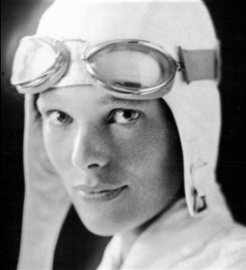
- 1. Amelia Earhart, “Queen of the Air” and the most famous woman in the world for a decade, disappeared en route to Howland Island in 1937, while attempting the first around-the-world roughly via the Equator flight with her navigator Fred Noonan.
-
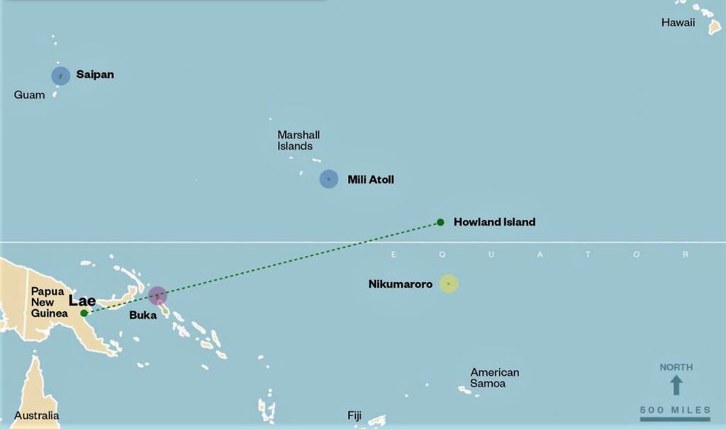
- 2. Map showing the Earhart/Noonan last flight, from Lae, New Guinea to tiny, hard-to- spot Howland Island. The direct distance was 2554 statute miles (2221 nautical miles). Various theories say they ended up in ocean near Howland, in the Marshall Islands, on Gardner Island (now Nikumaroro), or back in New Guinea at Buka.
-
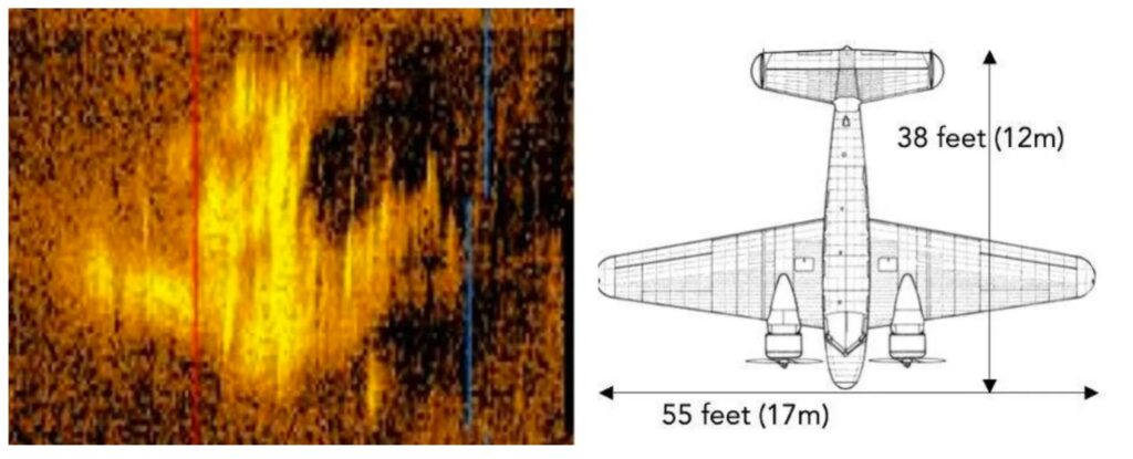
- 3. The original Deep Sea Vision image of the possible Earhart Lockheed Electra, spotted by the DSV team in early 2024 in 16,000 feet of seawater west of Howland. On the right is an overhead plan of the Electra.
-
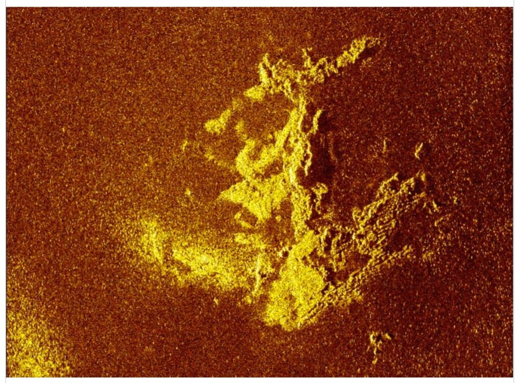
- 4. The final DSV image, from late in 2024, showing that the anomaly was, sadly, just a pile of rocks.
-
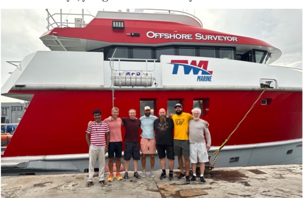
- 5. The DSV chartered vessel and some of the 16 crew, who crowded onto the rather small ship for over a month.
-
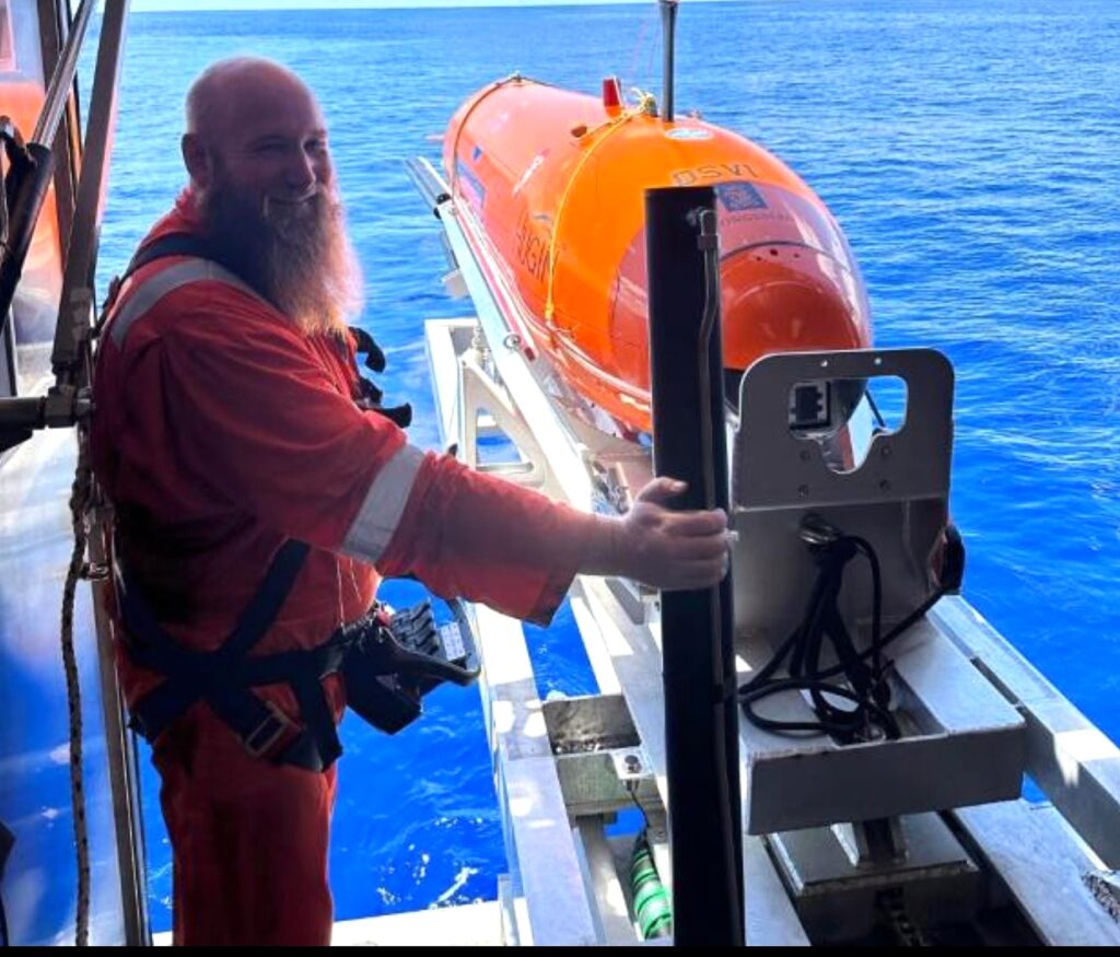
- 6. A DSV crew member prepares to launch the 18-foot, multi-million-dollar autonomous underwater vehicle “Miss Amelia Pollywog,” a reference to Amelia Earhart’s nickname of “Millie.”
-
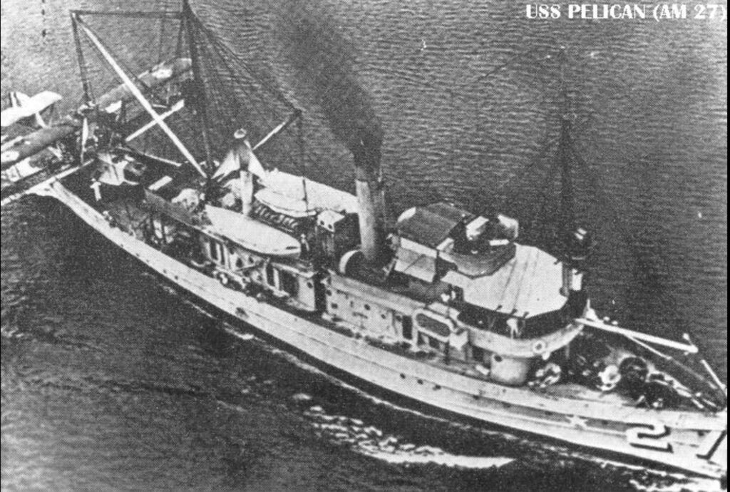
- 7. Naval aviators from the USS Pelican photographed Gardner/Nikumaroro Island in 1939, just two years after the disappearance. Note the crane and amphibious biplane on the stern.
-
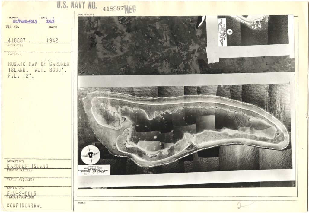
- 8. A cardboard card about 10”x 12” found at the US National Archives II in College Park by the author provides a photo of a photo mosaic taken on April 30, 1939, by the amphibious float plane launched from the USS Pelican. This high-quality image and card had never been found before by Earhart researchers.
-
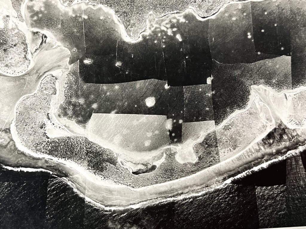
- 9. A closeup of the Gardner/Nikumaroro lagoon reveals details that could be useful in a search for remains of Earhart’s Lockheed Electra. Have a look at the point hanging down from the north, which is created by debris and sand washed in from the shallow lagoon entrance (called the Tatiman Passage), on the far left of the image. See anything?


Comments are closed.