Permit No, Permit Yes
Last summer and fall I wrote in this column about an expedition planned for November 2025, that hoped to find Amelia Earhart’s Lockheed Electra off Taraia Point on remote Nikumaroro atoll in the little-known Republic of Kiribati. I worried that the expedition would not get its permit from the Government of Kiribati (GoK), due to Chinese objections.
But I was only about one third right. The expedition has now received its permit (congratulations!); the Chinese apparently approve; but the permit was delayed by almost a year while the GoK set up a more robust permitting process. This delay cost the expedition, led by Dr. Rick Pettigrew of The Archaeology Channel, and partial sponsor Purdue University, into the six figures in additional expenses.
The recently approved permit will allow the expedition to arrive on Nikumaroro (formerly Gardner Island) on about October 12, 2026, and spend five days at Taraia Point, looking in the atoll’s lagoon just off the Point. The team is limited to a small area of the Point, about the size of half a football field, and will not be allowed to excavate other sites of interest on the island. The is unfortunate, because there are several other sites on the island that could use additional study. These include:
- Site Zero, on the northwest coast, where Earhart and navigator Fred Noonan may have first come ashore and set up camp.
- The Seven Site, on the southeast corner of the island, where previous excavations by TIGHAR (The International Group for Historic Aircraft Recovery, of which I am a member) and National Geographic found substantial evidence that a castaway lived and died there (but no absolute proof that that was Earhart), and where forensic dogs alerted to human remains. (I was fortunate to be on that 2017 expedition.)
- The prehistoric graveyard, on the north elevated coast, where ancient burial stones were found. This site has nothing to do with Earhart/Noonan, but investigations there could lead to a better understanding of the island’s culture and history.
The Plan: Phase 1
So, what will be done? Phase 1 will be just getting there. IMHO, this will be Hell on Earth. When I went in 2017, we had a small cruise ship, with meeting rooms, private or semi-private cabins, decent regular meals, and – most important – air conditioning! The ship was not great, it was not really designed for open water passages (835 nautical miles; 960 statute miles) and hence rolled a lot, and the captain drank a lot. But overall it was in the acceptable range.
My sources say that the proposed vessel, supplied by the GoK and the Chinese (!), is a smaller, rough cargo/passenger vessel with a front unloading ramp, not enough cabins to sleep all the team and crew, and apparently no air-con. Hence many members of the team will be sleeping on deck, in the open, subject to rain, storms and heightened El Nino effects. Small individual coffin-shaped capsules will be provided to shelter the sleeping crew from the weather, but in the very high humidity and temperature averaging 86 degrees Fahrenheit with oppressive humidity, the team will suffer. The sleeping areas are all high up on the vessel, and thus rolling will be accentuated, and six days of seasickness may result. (I recommended the team take Stugeron, the British anti-seasickness med that worked well for me and others when I sailed on a tall ship from Fiji to Vanuatu. This excellent med is not available in the US except by delivery from Britain, in small amounts and under certain conditions.)
The team will go ashore in two Zodiacs and possibly one raft-like structure, all with 40 HP outboards. This is the most dangerous part of the exped, since the narrow passage through the reef has very sharp coral edges and is calm only during slack water. Five days of work at the Point will likely involve at least 20 tricky trips through the passage.
Once on shore the crew and team will need to re-hack the trail across the island, avoid the 20-inch-wide coconut crabs (and not get bitten or kill them for their meat), take small craft across the lagoon ferrying gear to Taraia Point, and get to work.
The Plan: Phase 2
Once in the target area, the initial activity will be what archaeologists call a “walkover.” This is usually just a slow walk over the ground, carefully looking for objects, clues and disturbed soil. On the Point this will likely be a “wadeover,” since the team’s theory is that the fuselage and one wing of the Electra are in shallow water just offshore. Unfortunately, the wading will be through sand mixed with bird guano and other thick muck. Visibility will likely be only a few inches, so feet and probes will do the searching. They are looking for the “Taraia Object,” a sausage-shaped item seen intermittently on satellite images.
Critics of the Taraia Object hypothesis state that this area was already searched or surveyed by sailors from the USS Bushnell just before World War II, by a New Zealand team before that, and by various TIGHAR teams since the 1980s. Some of these efforts were a bit further off the Point, but it seems likely that any object as big as the Electra fuselage (38 feet), even if flattened, would be noticeable. Critics feel that the Object is a cluster of palm trees washed up to the Point by storms.
After wading, the team will not use SCUBA tanks, since the water is shallow (only 5-15 feet). Instead, a surface-supplied air (SSA) system (also called Brownie’s Third Lung or a hookah system) will be used. This has a floating air compressor on the surface that sends compressed air in long hoses down to the divers, and is usable down to 40+ feet. This approach saves an immense amount of weight, gear, expense and safety worries compared to a SCUBA search.
Sonar and magnetometers will also be employed. If warranted, a small dredge will be used to remove sand and muck and place it on the beach. If the Object is found, it will be examined for identifying information (numbers, rivet patterns, windows, engines, etc.), covered with a large tarp, and re-covered with sand for a future recovery expedition.
The 16-person team includes two commercial astronauts affiliated with Purdue, a paramedic, medical doctor, and four videographers. The latter will make a film of the entire expedition, whether successful or not, and will also live stream from the island.
$$$$$
The cost of this impressive effort is likely pushing $1 million. It appears that much of this cost will fall onto Rick Pettigrew and his archaeology channel and his other entities, unless the plane is found. I certainly wish him and his team good luck, fair winds, calm seas — and cool weather!
Links:
Archaeology Channel briefing on the Taraia Object: https://www.archaeologychannel.org/taraia/
Purdue YouTube on backing the expedition in 2026: https://www.youtube.com/watch?v=CvB0RsemEIg
(NOTE: live streaming from Nikumaroro is tentatively planned, and will likely be available from The Archaeology Channel and/or Purdue University)
Previous Toulmin Travel Tales columns on Earhart and the search, 2025:
https://www.mymcmedia.org/will-amelia-earhart-be-found-next-year/
https://www.mymcmedia.org/new-developments-in-the-search-for-amelia-earhart-part-1/
https://www.mymcmedia.org/new-developments-in-the-search-for-amelia-earhart-part-2/
Previous relevant Toulmin Travel Tales columns, from 2021:
https://www.mymcmedia.org/blog-latest-developments-in-the-search-for-amelia-earhart-part-1/
-
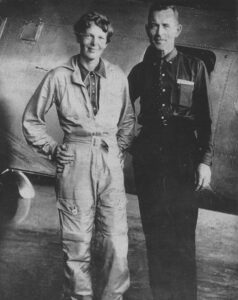
- 1. Amelia Earhart and navigator Fred Noonan disappeared on July 2, 1937, somewhere in the north or south Pacific Ocean, when heading for Howland Island (about 350 nautical miles NNW of Nikumaroro). They are standing in front of their Electra. Fred was a renowned Pan Am Clipper master navigator who pioneered routes across the Pacific. In the noisy Electra he was completely separated from Amelia by large gas tanks, and had to pass notes and calculations to her via a long bamboo fishing pole.
-
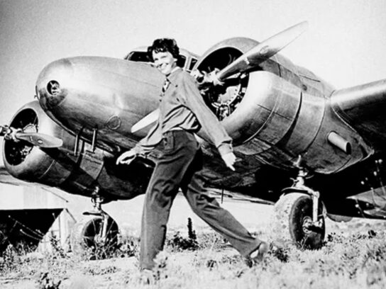
- 2. Amelia in front of her beloved Lockheed Electra 10 E, custom designed for her pioneering round-the-world flight. She almost made it.
-
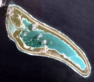
- 3. Overhead satellite shot of Nikumaroro atoll in the Republic of Kiribati (pronounced Kiribahss). The Republic, including its ocean component, is as large as the continental US, but few Americans have heard of it! Taraia Point projects into the lagoon in the upper right corner. It was created over the millennia by debris and sand washed in from the opening to the Pacific, in the upper left.
-
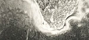
- 4. A closeup of Taraia Point obtained by the author from the National Archives II in Maryland. This previously undiscovered image was taken by a float plane from the USS Pelican shortly before World War II, and shows a dark tear-shaped item near the tip of the Point. Is that part of the plane?
-
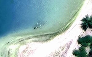
- 5. Rick Pettigrew, PhD, a registered professional archaeologist at The Archaeology Channel, compiled images of the Point (including one supplied by the author) and concluded that this item seen intermittently just north of the Point was likely Earhart’s Lockheed Electra 10 E. This is the “Taraia Object.”
-
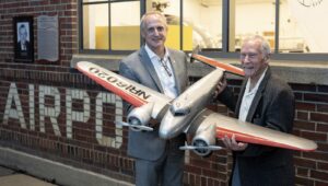
- 6. Steven R. Schultz (left) of Purdue (University) Research Foundation and Rick Pettigrew at the Amelia Earhart airport at Purdue University in Indiana, with a model of the Electra. Amelia planned to donate the Electra to the University upon her return, and substantial Earhart archives are located there. Steve and Rick will both be on the October expedition.
-
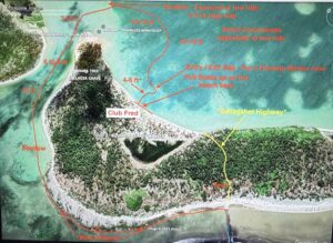
- 7. Chart showing the route into the island. The narrow, dangerous entrance channel is at the bottom. Once on the beach, explorers carry their gear on the “Gallagher Trail” – now likely overgrown – to the lagoon, then take a skiff or Zodiac to Taraia Point (out of frame on the top).
-
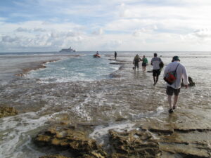
- 8. The narrow channel blasted through the reef decades ago. The water is calm here at slack water, and boarding the Zodiac should be easy. But waves and higher tides and the sharp, slick coral can make boarding dangerous. This photo is from 2017, with the expedition’s small cruise ship, holding 65 people and four HHRD (historic human remains detection) Border Collies, in the distance.
-
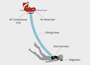
- 9. The type of “hookah” breathing system to be used by divers on the expedition. Multiple divers can get tubes from the floating air compressor, and dive down as deep as 40 feet or more, depending on the model used.